Arabs in Pittsburgh
February 11, 2015
Religion in the Pittsburgh Region
February 11, 2015 If cities were alive, rivers would be their arteries. Since time immemorial, rivers have been the lifeblood of civilization. The greatest cities in the world are all built on rivers. The area around the Tigris and Euphrates in Mesopotamia is known as the “Cradle of Civilization”. This is the area believed to be the cite where nomads first settled.
In Pittsburgh, we owe the existence of our own city to its three rivers: The Allegheny, Monongahela, and Ohio. But what was here before the skyscrapers of glass and steel?
Before the last Ice Age, the Monongahela and Ohio Rivers flowed north, emptying into Lake Erie. When encroaching glaciers blocked the southern shore of Lake Erie, jamming it with ice, the streams and rivers flowing into it backed up. As the glaciers receded and the ice melted, an area accustomed to a harsh freeze-thaw cycle experienced its most intense one ever. Land that was once buried under the weight of tons of ice thawed, expanded, and rose 350 feet. This ridge of higher land formed just south of Lake Erie, causing the streams and rivers south of it to flow toward Pittsburgh.
Early Human Habitation
 Artifacts found at the Meadowcroft Rockshelter, a massive rock overhang in Washington County (used by some of the area’s earliest inhabitants for shelter) provides clues as to what life was like here 16,000 years ago. Meadowcroft is situated on a tributary of the Ohio River and is the oldest known site of human habitation in North America. It was discovered in 1955, but it wasn’t until 1973 that professional excavation began.
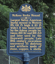
The Adena culture followed. These ancient ancestors also made their homes near the rivers. The Adena built huge burial mounds near what is presently McKees Rocks, five miles from the head of the Ohio River. Growing out of the Adena was the Hopewell culture, an ancient Indian civilization. The Hopewell people lived in villages scattered around the Ohio River.
By the time Europeans arrived in the New World, Native American cultures were well established. Iroqois, Lenape, Seneca and Shawnee inhabited our region. In the early 1700s European traders followed. In 1717, Michael Bezallion, a trader, was the first to describe the area’s rivers in writing. The Europeans must have liked what he had to say, because by the end of that year new outposts and settlements were being established.
George Washington and the French
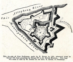
The French were the first Europeans to settle in any significant numbers at the confluence of the Allegheny and Monongahela Rivers. They recognized this area as prime real estate; therefore, this land near the rivers became the focus of battles for domination of the new world. The rivers provided easy transportation and served as trade routes. Concerned that the French were getting a foothold in the region, the British sent a young officer by the name of George Washington to warn the French to give up the land. In the mid-1700s the French and British battled over control of the area around the three rivers until the British ultimately took permanent control in 1758, establishing Fort Pitt and what later became Pittsburgh.
Boat Building and the Port of Pittsburgh
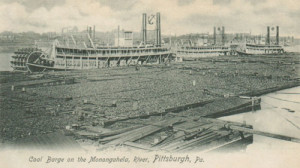
 Because the Ohio River flows west, Pittsburgh became the debarkation point for pioneers heading for the frontier, earning the city the nickname “The Gateway to the West”. Consequently, one of the city’s earliest industries was boatbuilding. In 1811 the first steamboat was built in Pittsburgh.
In addition to the rivers, Pittsburgh was blessed with an abundance of natural resources. Combine those with our navigable rivers, and the area soon became a manufacturing powerhouse.
According to the U.S. Army Corps of Engineers, the Port of Pittsburgh is the second busiest inland port and the 17th busiest port of any kind in the country. Many people erroneously believe that the area’s series of river locks and dams were designed to limit flooding. They were, in fact, designed to keep our rivers navigable. Before the corps built them, sometimes the depth in spots of our rivers fell to 12 inches, making them unable to support boat traffic. The dams constructed on the rivers act as an “aquatic staircase,” allowing the water level to be controlled. The rivers are maintained at a depth of 9 feet.
River Recreation
 Practical reasons are not the only reason that Pittsburgh reveres its rivers. Our three rivers provide much beauty and pleasure. In the 1800s, Pittsburgh was a major rowing capital; 20 boathouses dotted the river banks. Recently, rowing has been making a comeback. The Three Rivers Rowing Association is one of the largest community-based paddling clubs in the nation. Fifteen high school and five college teams row out of the TRRA’s facilities in Millvale and Washington’s Landing. The TRRA also offers kayaking and dragon boating programs.
But perhaps paddling doesn’t float your boat. In that case you’d be welcome aboard The Gateway Clipper fleet. During the 1950s, John E. Connelly realize how much of Pittsburgh’s lifeblood was its rivers. He purchased a riverboat, and in 1958 launched the Gateway Clipper, which provided pleasure boat tours of the rivers. The tours became so popular that in 1959 Connelly added two more boats to the fleet. They were the Gateway Clipper II and the Good Ship Lollipop. In 1987 the largest boat to ever sail the area’s rivers, The Majestic, joined the fleet. More than 25 million passengers have sailed with the fleet during the last few decades. This makes the Gateway Clipper Fleet the number one non-sports attraction in the city.
If history is any indicator, as long as rivers run through the area, people will keep flocking to them to work, play, and live.
By Janice Lane Palko


